
The centerpiece of one of the first farmer-led conservation efforts in the U.S., a dam built in the 1950s to protect Preston from flooding, is being restored to its original capacity.
The dam southwest of town maintained its flood-control function. But in 60-plus years, 15,000 cubic yards of topsoil filled the settling pond behind the earthen dike. By excavating that 7- to 9-foot-deep layer, this fall contractors renewed the East Willow Creek Flood Control Project’s dual purpose: flood control and sediment retention.
Work started November 20 and continued into December.
“It’s basically going to restore the ability of that watershed to hold the sediment back for another 30 years,” said Pete Fryer, the Lewiston-based lead engineer with the Technical Service Area 7 Joint Powers Board. The TSA assists member soil and water conservation districts.
The dam cost $39,531 in 1955.
Building a similar structure today could cost well over $500,000, Fryer estimated.
Kevin Kuehner, Preston-based soil scientist with the Minnesota Department of Agriculture, said with good weather and soil conditions, restoration costs are expected to come in well under the $226,000 budgeted in a Clean Water Fund grant from the Minnesota Board of Water and Soil Resources.
“The dike itself was in excellent shape, and the pipe as well. It was a poured-in-place outlet for the dam,” Fryer said. “Everything else was really good. The only thing it needed was to rehabilitate its sediment storage.”
Sediment was flush with the lower inlet. The pond was farmed in recent years.
The poured concrete two-stage drop-inlet structure was designed to allow high flows through the top inlet, lower flows through the bottom inlet. The 494-foot-long earthen dam rises 24 feet from the lower inlet. Aside from tree and brush removal, the structure itself didn’t require maintenance.
It became operational in fall 1955. The principal spillway was designed to temporarily hold nearly 23 million gallons of water. The emergency spillway was designed to hold 68 million gallons.
“It still functions from a flood-control standpoint, but once you get water in it, it’s going out almost immediately. It doesn’t have the pool area available for water storage,” Fillmore SWCD Administrator Donna Rasmussen said during an early September site visit.
“The other part of it is the sediment doesn’t have a chance to settle out. So, especially in a large rain event, that sediment is not being stored there anymore,” Rasmussen said.
About 2,000 acres – roughly half of the Crystal Creek watershed – drain through the four-foot-wide concrete outlet. Crystal Creek drains into Willow Creek, which empties into the South Branch Root River and eventually the Mississippi River. The South Branch Root River runs through Preston.
Large floods that swept through Preston in 1942 and 1950, plus excessive soil erosion prompted farmers to organize in the 1950s. Besides this dam and five others, that 17-member steering committee brought conservation practices such as contour strip cropping and grassed waterways to the landscape.
“When you think about it, over 60 years ago the concept of watershed management was a pretty new approach, yet they had remarkable success and participation,” Kuehner said.
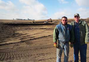
Contour strips, grass waterways and terraces installed over the years remain intact on the Mensink farm, where, in the 1950s, Art Mensink allowed the East Willow Creek Flood Control Project to be built on his property.
John Mensink, who took over the 240-acre farm from his father, agreed to the rehabilitation. After John died, his sons Rick and Mark took over.
“The recent rehabilitation of this structure by the Mensink family continues the legacy that their grandfather started in the 1950s. We’ve come full circle because there is a renewed interest to maintain practices that were installed back then and add additional practices in this watershed,” Kuehner said.
Considered among the most successful of 50 pilot projects across the nation – and the first in Minnesota – the dam was featured on a 1960s poster and postcards promoting conservation – and the beauty of the Midwestern landscape – throughout the U.S.
Rick, 63, recalled being surprised to see his farm on a poster in Mitchell, South Dakota’s Corn Palace during a family vacation.
The aerial view depicts a narrow corridor of water flowing out of the massive, neatly trimmed dam holding back what appears to be a small lake set amid crop contours in alternating hues of green.
When he was growing up in the early 1960s, Rick recalled he and a neighbor built a makeshift canoe to paddle in the pond. They launched from a dock made out of an old barn door and a couple of fence posts.
“Every time we’d go out with that canoe, it would fill up with water. We’d have coffee cans (to bail water). It would sink and we’d come walking back,” Rick said.
The pond once attracted ducks, geese and waterfowl hunters. Once it filled in, his father farmed the land. At times, it produced good corn crops. At times, the spring-fed site was too wet to harvest.
“We’re not really getting anything out of it,” said Mark, 52.
Rick agreed.
“We got a wet year a year ago, and it was too wet to get the beans out. I said, ‘Well, we’re not going to plant this anymore because you’ve got three acres of bean seed and fertilizer and spray and everything. We might as well let them dig it out the way it was,’” Rick said.
The brothers visited the site nearly every day during construction.
“I never realized it (the soil) was that deep. They’re going by the specs of how it was built the first time,” Rick said.
The Minnesota Board of Water and Soil Resources’ mission is to improve and protect Minnesota’s water and soil resources by working in partnership with local organizations and private landowners. Website: www.bwsr.state.mn.us.
Root River Field to Stream Partnership
The Crystal Creek watershed dam restoration is the largest single project of 160 planned conservation practices within the Root River Field to Stream Partnership.
The Minnesota Department of Agriculture-led venture tracks what effect agricultural practices have on fields, rivers and streams. Intensive monitoring is focused on three small watersheds within Houston, Fillmore and Mower counties.
What is learned from the dam restoration within the Crystal Creek watershed could help quantify sediment reductions from similar projects throughout southeastern Minnesota.
Crystal Creek watershed flood control structures and other upland conservation practices – such as waterways, contour strip cropping and hay fields – likely account for per-acre sediment loss rates that are half that of similar watersheds. Allowing the soil to settle in a retention pond also cuts the amount of soil-attached phosphorus and nitrogen that enter downstream waters.
“The reason it’s of interest to (the Field to Stream) project is that it drains about half the study watershed,” said Donna Rasmussen, Fillmore SWCD administrator. “The opportunity with the monitoring that’s going on is that we can see what the water quality effects are by rehabilitating the structure and adding storage capacity back by cleaning out the sediment and restoring it to its original design.”
Restoration and the Root River
By curbing peak flows and reducing storm runoff, the dam also could help reduce streambank erosion. A 2015 sediment source study revealed that streambank erosion accounted for 43% of the 280,000 tons of annual sediment loss at the mouth of the Root River near Hokah, Minn. “This study indicated that the Root River is very sensitive to erosive streamflow. Anything we can do to slow down the movement of excessive runoff can help reduce streambank erosion sources downstream,” said Kevin Kuehner, a soil scientist with the Minnesota Department of Agriculture.