
Photo submitted
The southern border of Houston County and Fillmore County is the Iowa state line. When settlers arrived in southeast Minnesota Territory in 1852, Iowa had been a state for six years. But the border was only a line on a map. On the ground, nobody knew where the Iowa border was.
When the territories of Minnesota and Iowa could not agree on a boundary, Congress intervened. Shortly before Iowa statehood in 1846, the border was set at the parallel of 43 degrees and 30 minutes north latitude, but in 1852, far northern Iowa was still frontier – uninhabited and unsurveyed, where bands of Sioux, buffalo and elk roamed the prairies.
A survey with mile-by-mile markings was needed so settlers, sheriffs and tax collectors would know where they were. The first step was to determine where 43 degrees, 30 minutes north latitude was. In the summer of 1949, Capt. Thomas J. Lee of the U. S. Topographical Engineers was sent to determine the beginning point of the Iowa-Minnesota border.
With astronomical readings of the stars and planets, taken from the Wisconsin side of the Mississippi River, Lee located the desired spot on the west side of the river. He marked the location with an iron obelisk, which due to no solid ground in the Mississippi flood plain, was placed three miles west of Minnesota’s southeast corner.
The six-foot-high, hollow cast-iron pillar weighed 600 pounds with the words engraved “Iowa” and “Minesota” (one ’n”) and “1849” and “ Lat. 43 degrees, 30.” It has been moved back from the side of a roadway after being hit by a car and stands near the highway and across the railroad tracks at the north edge of New Albin, Iowa. Another cast-iron marker explains its significance. It is known as the “Iron Post” and listed on the National Register of Historic Places.
It was cast in a Wisconsin foundry and taken across the frozen Mississippi River by ox team – probably to Lansing, Iowa, where Capt. Lee paid $57 for it.
Of the more than 500 hundred stone, wood and earthen markers eventually set along the 269-mile border, it is the only one remaining. Using the iron post as the base point, the border survey was to begin the next year (1850), but an epidemic of Asiatic cholera delayed it until 1852.
Heading west from the Iron Post followed only the north-south position, but not the east-west position. From a known Iowa survey to the south, the surveyors walked north until they met the line drawn west from the Iron Post.
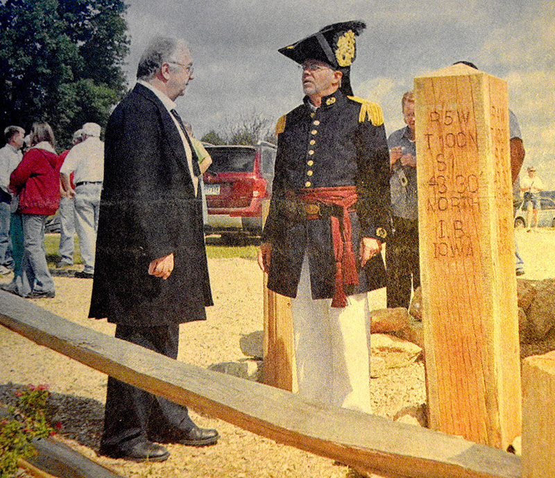
This intersection was termed the “Initial Point” of the survey. It was marked by an eight foot long white oak post, 12 inches square and branded on the four sides. Upon the sides facing southeast and southwest were the letters “I.B. Iowa 43 degrees, 30” North.” On the sides facing northeast and northwest were the letters “M.B. Minnesota 43 degrees, 30 North.”
The original Initial Point post has not survived, but a replica was installed along with a kiosk (sign with roof above) with costumed re-enactors taking part in the dedication ceremony on September 11, 2010. The site is a wayside on the south side of Houston County road No. 2 and Allamakee County road A-11 halfway between Eitzen, Minnesota, and New Albin, Iowa. The highway has two designations as it jumps back and forth from Minnesota to Iowa.
The state line was to extend from the middle of the main channel of the Mississippi River to the middle of the main channel of the Big Sioux River. The survey of a degree of latitude more than 250 miles posed a problem. Because of the curvature of the earth, the line curves constantly but slightly to the north. The line would mark sections and townships and serve as a baseline for all future surveys in not only Minnesota but also the Dakotas.
The 43-man expedition, led by Capt. Andrew Talcott, consisted of 14 surveyors, a doctor, a hunter, an interpreter and four cooks along with chainmen, flagmen, monument builders, teamsters, wood choppers and general handymen.
Two young men were the sons of Congressmen, another the son of an ex-governor of Kentucky. Some of these young men had an undisciplined past, and their parents had persuaded them to join the expedition, which would be conducted with strict, almost military discipline. Each man pledged not to possess, transport or drink intoxicating liquor.
The equipment included a thousand pounds of instruments and books, a dozen forks, a box of lemons, a very large tin wash basin and mess furniture to accommodate four parties of 10 persons each. All of this was shipped to Lansing, Iowa, the nearest steamboat landing. Every man could bring as much as 50 pounds of personal baggage.
There were so few white settlers that the expedition saw only one farm, that of Henry Robinson about four miles west of Eitzen.
Capt. Talcott had previously been advised by his superiors to take care as the expedition, from almost start to finish, would travel through country inhabited by Sioux Indians, which although not hostile, might steal horses and provisions. The Sioux were suspicious and unfriendly and frequently asked the interpreter why the expedition was there.
While surveying the state line, a sod monument was placed every five miles. They were to be about three feet feet high and three feet square at the base. Every 50 miles, a granite boulder was placed. Sometimes, men had to travel a day for more to find a suitable rock, which might weigh as much as a ton. They had special vehicles to haul them by ox teams. Before the boulder was placed, a glass bottle was buried on the spot with paper inside, containing mathematical surveying calculations.
The expedition reached the Big Sioux River on July 21, haven taken three months and three days. At some time later that summer, the flood plain was dry enough to survey the three miles between the Iron Post and the Mississippi River.
Sources: the collected research of Jan Lee Buxengard, including her article, “Historic border marker dedicated,” Spring Grove Herald, September 29, 2010; “A Fascinating Report By Boundary Surveyors, the Story Behind an Early Iowa Land Swindle,” by Otto Knauth, Des Moines Sunday Register, July 12, 1970; Now and Then, by Summer Sheldon, 1986; “New Albin Iron Post is Historical Marker with Interesting Past,” by Barbara K. Cain, Allamakee Journal, October 7, 1992; “From which all property originated,” by Craig Moorhead, Houston County News, September 16, 2010
Leave a Reply